ÜRÜNLER

ÜRÜNLER
GPS/DGPS
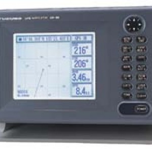
FURUNO GP-150
Furuno GP-150 fully satisfies the requirements of IMO Res. 112 (73), and IEC 61108-1 . Support DTM, suitable for connection to VDR / SVDR (black boxes). Excellent sensor absolute speed (SOG) and the absolute rate (COG) for AIS, radar and other navigational equipment. Signal amplification system using WAAS (standard) and DGPS (optional). Display modes: Videoprokladchik, three-dimensional path route Broadband, text, etc. Memory: 2000 points of track route, 999 waypoints, 30 routes with 30 waypoints route
| Functions | ||
| The main function | MSC.112 (73), IEC 61108-1 Dop.2 | A.819 (19), IEC 61108-1 Dop.1 |
| Accuracy | 13 m (95%) | 100 m (95%) |
| Ground speed | Compliance with equipment to measure speed and distance (SDME) | No |
| Absolute Rates | Accuracy ± 1 ° (> 17 knots), ± 3 ° (<17 knots) | No |
| Coordinated Universal Time | Output | Data only for the latitude / longitude |
| Autonomous monitoring of the accuracy of data receiver (RAIM) | Displays reliability security and warns unsafe levels of confidence (10 and 100 m) |
No |
| Technical characteristics | |
| Receiver | |
| Receiver Type | 12 discrete channels, C / A code accuracy |
| Reception frequency | L1 (1575,42 MHz) |
| Time to first observation | 12 sec |
| Speed range | 900 nodes |
| Geodetic System | WGS-84 (NAD-27 or others selectable) |
| Update information | 1s |
| Increased accuracy DGPS | |
| DGPS | |
| Radio stations diffpopravok | Automatic or manual selection of a frequency. |
| Frequency band | 283.5 - 325.0 kHz, 0.5 kHz through |
| Message Format | RTCM SC-104 Ver 2.0 Type1, 7, 9, 16 |
| WAAS | |
| Standard built-in display | |
| Accuracy | |
| GPS | 10 m (95%) |
| DGPS | 5 m (95%) |
| WAAS | 3 m (95%), limited coverage |
| SOG | ± 0.001 knots (calm sea) |
| COG | ± 3 ° (SOG 1-17 knots) ± 1 ° (SOG> 17 knots) |
| Display / Videoplotter | |
| Screen | 6 'LCD display (120x91 mm), 320x240 pixels |
| Picture Modes | VideoPlotter, Highway, Text, Steering |
| Videoprokladchik | Scale: 0.02 - 320.0 nautical miles Interval: 1 sec - 60 min 0.01-99.99 nautical miles |
| Memory | 2000 pt. follow the trajectory, 999 waypoints, 30 routes with 30 waypoints route |
| Signals | Arrival, anchor watch, deviation from track (XTE), DGPS-signal, time, speed, WAAS, disable the device, depth |
| Indication of reliability | Safe, Cautions and Unsafe levels (10-100 m) |
| Interface IEC 61162-1 Ed 2, NMEA 0183 | |
| Exit | GBS (error satellite), GLL (L / L), VTG (SOG, COG), ZDA (UTC), WPL, etc. |
| Input | DBT (Depth), HDT (Compass), MTW (water temperature), TLL (TGT L / L), VBW (Dual Rate absolute / relative to the water), etc. |
| Operating conditions | |
| Temperature | -15 °C - +55 °C (display) -25 °C - +70 °C (antenna) |
| Waterproofing (according to IEC 60529) | IPX5 (display) IPX6 (antenna) |
| Food | |
| 12-24 VDC, 0.8-0.4 A | |
PACKAGE
Standard
Additional
Ürün Kodu: GP-150
Ürün Grubu: GPS/DGPS